

Geomatics Projects
Geomatics is an applied science, not a skill. GIS is a tool.
Albian-Geo provides geomatics, survey-control and spatial-data management capability for projects where positional accuracy, geodetic control, field survey quality and spatial data integration are critical.
Experience includes geomatics department management, survey subcontractor oversight, geodetic network maintenance, GNSS and land-survey quality control, drone and laser-scan survey advocacy, spatial database review, pipeline route desk studies, remote sensing, field mapping, geotechnical investigation support and technical mentoring.
The objective is to make spatial data technically defensible, correctly controlled and useful to engineering, geotechnical, environmental and project-management teams

Geomatics technical management
Survey subcontractor oversight, HSE/method review, client liaison and QA

Geodetic Control
Primary survey network maintenance, re-observation and adjustment

Survey quality assurance
Identification of poor survey practice, method statements and contractor review

Spatial data governance
Unified spatial database review, spatial data harmonisation and knowledge-gap assessment

Engineering and geotechnical support
Borehole location planning, soils mapping, groundwater table and volumetric assessment

Pipeline route planning
ROW desk study, obstacle/crossing identification and phased route-design suppor
Key Capabilities
Geomatics Department Management and Spatial Data Governance - Southern Iraq


Contract and budgetary management of subcontractor survey and geotechnical teams.
-
Site visits to ensure compliance in HSE and technical methodology
Technical management of geomatics survey
-
Client technical liaison
-
Advocating for drone and laser scan surveys
-
-
Defining technical objectives and quality objectives for work and variation orders
-
Managing department quality assurance and implementing change
-
Managing multi-stakeholder expectations in a diverse and dynamic operating environment.
-
Identification of spatial data knowledge gaps and remedy planning:
-
Lack of unified spatial database
-
Volumetric assessment of borrow pits and contaminated ERW spoil
-
Engineering soils mapping and groundwater table
-
Legacy contamination monitoring
-
-
Maintaining geodetic network for use by all stakeholders
Mentoring junior surveyors.
Preparation of technical training material
-
Weekly 'good to knows' and other precis
Geotechnical Investigation Design
-
Investigative boreholes and sampling locations
-
Management of technical report writing
-
Interface management for geotechnical investigation planning

Geotechnical training material

Cross disciplinary water resources support where specialist groundwater capability was required
AIM: Provide water for irrigation projects
-
Desk study and appreciation of all water sources:
-
Precipitation,
-
Conjunctive river use
-
Groundwater
-
Sewage
-
-
Recommendation of best course of action
-
Test local groundwater for quality and quantity
-
-
Supervision of all works, sampling and aquifer pumping tests
-
Critical evaluation of contractor capability and performance review


Potential water sources: groundwater and treated sewage effluent
Multidisciplinary technical support beyond core geomatics - support to Government Solutions Dept
AIM: Provide site characterisation and water for a new city/town development in Southern Iraq
-
Project in support of Government of Iraq
-
Desk study and appreciation of all water sources:
-
Precipitation, groundwater, local surface water from Al-Teeb River
-
-
Identification of surface and near surface geology
-
Technical report writing and presentations
-
Identification of possible course of actions:
-
Managed aquifer recharge and water harvesting
-
-
Conceptual calculations
-
Knowledge gap assessment /identification
-
Field reconnaissance
-
Geo-spatial support to multidisciplinary technical team
-
Prepared pilot study scope of works for site characterisation


Technical project management for geomatic surveys in Southern Iraq oilfields


Identification and elimination of poor survey practices.
Writing robust technical method statements for internal training and Client use and proposals.
-
Design and management of primary survey network re-observation adjustment
Assistance to regional business development team on a number of successful high profile and prestigious projects:
-
Forensic study of third party survey quality in preparation for possible litigation procedures (Kuwait)
-
Geodetic network densification and gravity model (UAE)
-
Spatial data harmonisation project (UAE)
Technical development of a contaminated-land and groundwater investigation business line, including competitor-positioning review, equipment selection, staff training, bid support and method-statement preparation.

Mentoring and Technical Education
Preparation of educational material to help explain and instruct colleagues in fundamental geomatics and geo-spatial principles.
Done in response to identification of basic knowledge gaps:
-
Scale factor for correction between UTM and Plant Grids
-
Why its in the wrong place...
-
-
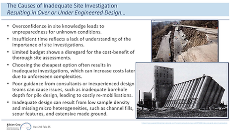
Importance of Geotechnical Investigations
-
Why your structure is sinking...
-
-
Estimating error in measurements
-
Translate the error into cost...
-


Desk study: pipeline right of way, Southern Iraq
Desk study for major IOC.
An 82 km natural gas pipeline Right of Way (RoW) from Al-Ratawi to Kor Al Zubair.
Low cost planning solution allowing a phased approach to route design and alignment.
Integration in GIS of ground truth geotechnical and remotely sensed data along RoW.
Over 1,000 obstacles and crossings with planning dimensions identified:
-
Highways, roads, tracks
-
Wadi (flash flood geo-hazards), slope, agriculture, contamination
-
Ability for planning team to selectively target difficult areas

Roosevelt Roads, Puerto Rico

Desk study and research projects:
-
Land use development
-
Pipeline ROW
-
Ocean Thermal Energy Conversion (OTEC)
Use of remote sensing and public domain data mining to provide formative information to assist Client's development expansion plans.
Identification of possible development issues such as:
-
Geo-hazards, shallow groundwater
-
Remnant underground utilities
-
Proximity to airport
-
Possible legacy ground contamination
Presentation highlighting integrated approach to pipeline ROW survey, land ownership and monitoring for potential project bid in Uzbekistan.
Introductory presentation on the technical considerations for the use of OTEC technology:
-
Client intending to apply for grants that require the development of this technology within region.


Field Mapping:
Sierra Leone, Afghanistan, UK, Spain & Iraq
Road and bridge mapping in support of UK and UN relief assistance to Sierra Leone Government.
Geological field mapping and interpretation
-
Training undergraduate students
Land navigation training to UK Military.
Remote Sensing
Management of imagery acquisition purchase for oil and gas projects in Iraq.
-
Including GCP and pre-making / ground control surveys for image orthorectification
Remotely sensed mapping to support UK Foreign Office policy and operations in Afghanistan.
-
NDVI studies
-
Use of proxy markers for security stability studies
-
Lights at night
-
Localised agriculture improvements
-
Traditional and remotely sensed geological field mapping.
-
Augmenting reservoir studies
Integration of multi-spectral imaging techniques and digital elevation models (DEM).
-
Feature extraction for mapping updates
-
Identification of geo-hazards for field development planning
-
Wadis (flash flooding), slopes,
-
-
Contamination
-
Legacy spills from conflict and field evaluation and attribution
-
-
Catchment characterisation
-
Supervised classification
-
Vegetation identification (crop analysis)...


Geodesy and Land Survey
Numerous worldwide positioning and mapping surveys in support of the UK Government and its allies.
-
Survey technical and logistical project management
-
Training, mentoring and teamwork
Classical survey and geodesy training (pre-GPS and electronic total stations!).
-
Foundation for future and successful GPS surveys.
-
Re-surveying of National primary survey control networks in Zimbabwe, Oman, Maldives and Malaysia
-
Gravity survey Maldives
-
Post conflict boundary survey, Bosnia IEBL
-


